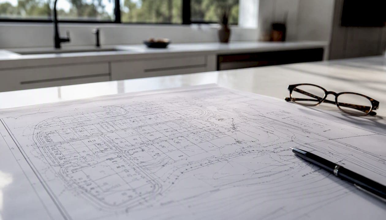
A plat map is a recorded, to-scale drawing that shows how land is divided into lots, blocks, streets, and easements. If you're buying or building in the U.S., this document tells you exactly where your legal lot lines fall, what easements cross your land, and what you can and cannot build. Pull it before you close, not after.
The rest of this guide covers how plats are created and recorded, the types you'll encounter, how to read every element on one, where to find yours, and when a recorded plat isn't enough.
Table of Contents
- What is a plat map, exactly, and what does it record?
- How does a plat map differ from a survey or a plot plan?
- Why plat maps matter before you buy or build
- How to read a plat map: key elements and a step-by-step checklist
- Where to find a plat map for a U.S. property
- How accurate are plat maps, and when do you need a licensed surveyor?
- How a local real estate agent can help you with plat maps
- Key Takeaways
- The detail most buyers overlook on a plat
- Work with Jeffsellssandiego on plat maps and San Diego closings
- Authoritative sources for official U.S. plat records
What is a plat map, exactly, and what does it record?
A plat is a cadastral map drawn to scale that shows divisions of land into lots, blocks, and streets. Once recorded, it often replaces section-based legal descriptions in deeds with simpler lot-and-block references. This shift from a dense metes-and-bounds paragraph to "Lot 7, Block 3, Sunset Hills Subdivision" is what makes plats so practical for everyday property transactions.
A licensed surveyor or developer's engineer prepares the drawing. It then goes through local planning board approval before a county recorder or recorder of deeds formally accepts and files it in the public record. "Recorded" matters because it gives the plat legal authority: title companies, courts, and lenders all treat a recorded plat as the authoritative source for lot lines and easements within that subdivision.
That authority has limits, though. A recorded plat may be decades old. Physical monuments in the field can be lost, moved, or buried. The drawing itself is authoritative for the subdivision layout, but it does not replace a contemporary boundary survey when you need to establish exact, enforceable corner locations on the ground.
How does a plat map differ from a survey or a plot plan?
These three documents get confused constantly, and the confusion can cost money. Here's how they actually differ:
| Document | Who creates it | What it shows | Primary use |
|---|---|---|---|
| Recorded plat | Licensed surveyor or developer's engineer; filed with county recorder | Subdivision layout: lots, blocks, streets, easements, setbacks | Legal description in deeds; title searches; permit applications |
| Boundary survey | Licensed land surveyor (field work) | Field-measured boundaries, monuments, structures, encroachments for one parcel | Resolving disputes; building near lot lines; lender requirements |
| Plot plan / site plan | Architect, engineer, or designer | Single-lot layout for a specific project: proposed structures, setbacks, utilities | Building permits; zoning applications |
Title companies rely on the recorded plat to confirm lot identity and easements. Permit offices want a plot plan that shows the proposed structure's relationship to lot lines. Courts and surveyors turn to boundary surveys when the recorded plat's dimensions don't match what's in the field.
For most residential buyers, the recorded plat is sufficient to understand what they're purchasing. Order a new boundary survey when you're building close to a lot line, when a neighbor disputes the fence location, or when the deed and plat descriptions don't agree. A plat of survey prepared by a licensed surveyor shows field-measured boundaries, monuments, structures, easements, and encroachments tied to the specific parcel, which is a different level of precision than the recorded subdivision drawing.
Why plat maps matter before you buy or build
Plat maps show property lines, lot dimensions, easements, setbacks, and road access — the exact details that determine what you own and what you can do with it. Skipping this check before closing is one of the more expensive mistakes buyers make.
Here's what a plat can reveal that affects your purchase:
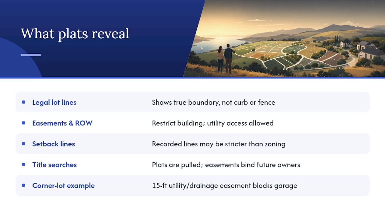
Legal lot lines. The curb is not your property line. Neither is the fence your neighbor installed. The plat shows where the legal boundary actually falls, which can differ from what's visible on the ground by several feet.
Easements and rights-of-way. Easements and rights-of-way shown on plats can limit where you build; check the plat before permitting work or building fences. A utility easement running along the rear 10 feet of a lot means the utility company has the right to access that strip. You own it, but you can't build a permanent structure on it. A drainage easement can be even more restrictive.
Setback and building restriction lines. These are separate from zoning setbacks. A subdivision's recorded plat may impose building restriction lines that are stricter than the local zoning code, and both apply simultaneously.
Title searches. When a title company searches your chain of title, the recorded plat is one of the first documents they pull. Easements and restrictions recorded on the plat run with the land, meaning they bind every future owner.
Property history and research. Plats record the original subdivision layout, which helps researchers trace ownership history, understand how a neighborhood developed, and identify when lots were combined or split over time.
A real-world scenario worth knowing: a buyer contracts on a corner lot planning to add a detached garage along the side yard. The recorded plat shows a 15-foot utility and drainage easement along that exact side. The garage plan has to move, or the project doesn't happen. That's a discovery you want before the purchase contract, not after the foundation is poured.
How to read a plat map: key elements and a step-by-step checklist
Every recorded plat contains the same core components. Once you know what to look for, reading one takes about ten minutes.
The title block and map basics
The title block sits in a corner of the drawing and contains the subdivision name, county and state, recording date, the surveyor's name and license number, and the recording reference (book and page or instrument number). A recorded plat includes a title block with subdivision name, county, surveyor details, scale, and legend that explains every symbol used on the map. The scale bar tells you the ratio of drawing distance to real-world distance. The north arrow orients the drawing to true north, which is important when you're reading bearings.
Lots, blocks, dimensions, and bearings
Each lot is numbered within its block. Lot lines are drawn with dimensions in feet along each side. Bearings (e.g., "N 45°30' E") describe the direction of each line using compass notation referenced to true north. Curved lot lines include curve data: radius, arc length, and chord bearing. If a lot line follows a curve, those three numbers define it precisely.
Monuments and benchmarks appear as small symbols (often a filled circle or an "X") at lot corners and along street centerlines. These are the physical markers a surveyor set in the ground when the plat was originally surveyed.
Easements, rights-of-way, and building lines
Easements are typically shown as dashed lines with a label ("10' U.E." for a 10-foot utility easement, "D.E." for drainage easement). Rights-of-way for streets are shown as the full width of the street corridor, not just the paved surface. Building restriction lines appear as a separate dashed line set back from the front lot line, marking the minimum distance a structure must be from the street.
Your checklist for reviewing any plat
- Confirm the title block: verify the subdivision name, county, recording date, and surveyor license number.
- Find your lot and block number and trace all four (or more) lot lines.
- Read the dimensions on each lot line and note any that seem shorter than expected.
- Identify every easement crossing the lot: type, width, and location relative to where you plan to build.
- Locate the building restriction line and compare it to your planned structure's footprint.
- Check the right-of-way width for any adjacent street, especially if you plan a driveway or fence near the street edge.
- Note the monument symbols at your lot corners and verify whether a recent survey confirmed those monuments are still in place.
- Cross-reference the plat's recording reference with the county recorder's index to confirm you have the current, unrevised version.
Pro Tip: If the plat is old, ask a licensed surveyor to locate the corner monuments before you finalize any building plans. Lost or disturbed monuments are common in older subdivisions, and the cost to have them re-established is far lower than a boundary dispute after construction.
Where to find a plat map for a U.S. property
Before you search, gather these identifiers: the property address, the parcel identification number (PIN or APN) from the tax records, the subdivision name if you know it, and the plat book and page number if it appears in the deed.
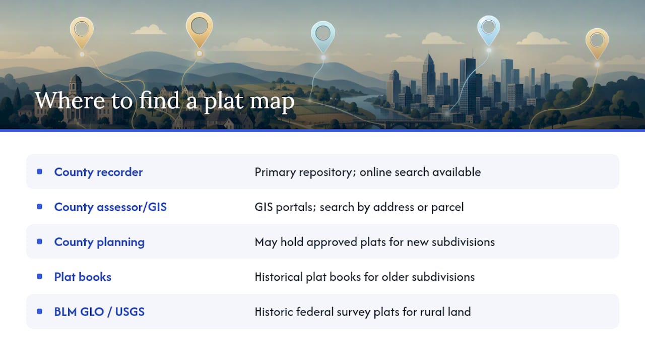
County recorder or recorder of deeds. This is the primary repository for recorded plats. Most counties allow in-person searches and many now offer online document search by subdivision name, book/page, or instrument number. Copies typically cost a few dollars per page at the counter; some counties offer free PDF downloads.
County assessor or GIS portal. Many county assessor and mapping departments publish GIS portals and plat indexes that let the public search for recorded plats and parcel maps. Search by address or parcel number to pull the plat layer, then download or print the relevant sheet. This is often the fastest free option for urban and suburban properties.
County planning department. For newer subdivisions, the planning department may have the approved plat on file before it's fully indexed in the recorder's system.
Plat books at public libraries. Many county libraries hold historical plat books, particularly useful for older subdivisions that predate digital records. The reference desk can direct you to the right volume.
USGS and BLM GLO records for older or rural land. The Public Land Survey System (PLSS) produced township and section plats that form the basis for many land descriptions across large regions of the United States. For rural or historically federal-surveyed land, BLM General Land Office records provide access to historic federal survey plats and patent records, useful when researching older or rural tracts.
Title company. If you're in a transaction, your title company will pull the plat as part of the title search. Ask for a copy of the plat sheet with your preliminary title report.
Cost and timing: free online downloads are available in most urban counties. Certified copies from a county recorder typically run $1–$5 per page. A title company's plat pull is usually included in the title search fee. Turnaround for online searches is immediate; counter requests at a recorder's office are usually same-day.
How accurate are plat maps, and when do you need a licensed surveyor?
A recorded plat is drawn to scale and legally authoritative for the subdivision layout, but "accurate" has a practical ceiling. Plats can be 30, 50, or even 100 years old. The bearings and dimensions are based on the original survey, which used the technology and standards of that era. Physical monuments set at lot corners can be lost to construction, landscaping, or simple time. The drawing may be correct; the ground may tell a different story.
Situations that call for a licensed boundary survey rather than relying on the recorded plat:
- You're building a structure within a few feet of a lot line (fence, addition, ADU, garage).
- A neighbor disputes where the boundary falls.
- You're splitting or combining parcels.
- The deed description and the plat dimensions don't match.
- You're buying rural or unplatted land where the legal description is metes-and-bounds.
- A lender or title insurer specifically requires a survey as a condition of closing.
Boundary survey costs vary by region, lot complexity, and how much research the surveyor needs to do. For a standard residential lot, expect a range from roughly $500 to $2,000 or more depending on the state and site conditions. Timeline is typically two to six weeks from engagement to final drawing. When hiring, ask for the surveyor's state license number, verify it with your state's licensing board, and request references from recent residential projects in your area.
How a local real estate agent can help you with plat maps
A knowledgeable agent does more than open doors. When it comes to plats and property records, a good agent pulls the county recorder and assessor records early, identifies the plat book and page from the deed, and flags any easements or building restriction lines before you spend money on inspections or design work.
In practice, that means requesting the plat sheet as part of the initial due-diligence package, reviewing it alongside the preliminary title report, and coordinating with a licensed surveyor when the plat raises questions. An agent who understands how to read a plat can spot a utility easement running through a proposed pool location or a building restriction line that makes a planned addition impossible, before those issues become renegotiation leverage for the other side.
For buyers relocating to San Diego, understanding the local subdivision structure matters. San Diego County has a wide range of recorded subdivisions, from older coastal neighborhoods with narrow lots and complex easement histories to newer master-planned communities with detailed CC&R packages that reference the recorded plat. Jeffsellssandiego works with buyers and sellers across San Diego neighborhoods, pulling plat records and coordinating title and survey work as part of the transaction process. The San Diego home buying guide covers the full due-diligence sequence, including when to request a plat review and what to do if the title report flags an easement issue.
Understanding why a residential realtor matters in home buying goes beyond negotiation. Plat literacy is one of the practical skills that separates an agent who protects your interests from one who just processes paperwork.
Key Takeaways
A plat map is a recorded legal document that defines lot lines, easements, and building limits, and reviewing it before closing is one of the most practical steps any buyer can take.
| Point | Details |
|---|---|
| Plat map definition | A recorded, to-scale map showing lots, blocks, streets, and easements; legally authoritative for subdivision layout. |
| Legal weight and limits | Recorded plats are authoritative for lot lines and easements but may be decades old; lost monuments may require a new survey. |
| Plat vs. boundary survey | A recorded plat shows the subdivision layout; a boundary survey field-measures a specific parcel's corners and encroachments. |
| Where to find yours | Start with the county recorder, assessor GIS portal, or title company; use BLM GLO records for older rural land. |
| When to hire a surveyor | Order a boundary survey before building near lot lines, resolving disputes, or when deed and plat descriptions conflict. |
| Jeffsellssandiego | Works with San Diego buyers and sellers to pull plat records, review easements, and coordinate surveys before closing. |
The detail most buyers overlook on a plat
Most buyers read the price, the square footage, and maybe the inspection report. The plat map sits in the title package, unread, until something goes wrong.
The easement issue is the one that comes up most often. A utility easement along the rear of a lot looks harmless on paper until the buyer decides to add a pool, a garage, or even a substantial fence. At that point, the permit office pulls the plat, finds the easement, and the project either moves or stops. The recorded plat had that information the whole time.
The other thing buyers underestimate is the age gap between the recorded plat and current field conditions. A subdivision platted in the 1960s may have had corner monuments disturbed by decades of landscaping, utility work, and construction. The plat says the lot is 60 feet wide. The fence your neighbor installed says something different. Neither the plat nor the fence is automatically correct; only a licensed surveyor can tell you which one matches the legal boundary.
My practical recommendation: get the recorded plat and the preliminary title report at the same time, read them together, and flag any easement, restriction, or dimension that affects your intended use of the property. Do that before you remove contingencies, not after.
Work with Jeffsellssandiego on plat maps and San Diego closings
Pulling a plat and knowing what to do with it are two different things. Jeffsellssandiego handles both for buyers and sellers in San Diego County, from locating the recorded plat in the county recorder's system to reviewing easement notes with the title company and coordinating a licensed surveyor when the situation calls for one.

If you're buying in San Diego and want an agent who treats the plat review as a standard part of due diligence rather than an afterthought, that's exactly how Jeffsellssandiego works. Browse current San Diego listings to see what's available, or visit the Buyer's Guide to understand the full transaction process, including title, survey, and plat review steps. Reach out directly to get started.
Authoritative sources for official U.S. plat records
Where to search depends on the property type:
- How to Read a Plat Map — Trust Compass
- Public land survey system (PLSS) — USGS
- GLO Records
- Washoe County Assessor Mapping
For most residential properties in an established subdivision, the county assessor's GIS portal is the fastest free starting point. For rural tracts or land with a metes-and-bounds description, go directly to the BLM GLO or USGS PLSS resources before spending time in the county recorder's index.